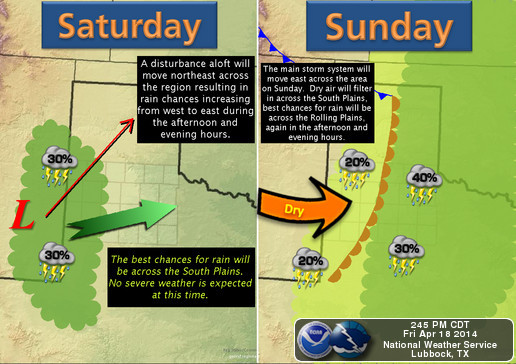
A storm system, approaching from the west, will bring increasing clouds and a chance of showers and thunderstorms early Saturday, through late Sunday afternoon.
As an area of low pressure organizes over New Mexico, southerly winds will pull deeper moisture back into west Texas. As this occurs, the storm system will work to ‘lift’ this moisture; producing clouds, showers, and eventually a few thunderstorms. While rainfall activity will not be widespread, a few areas could receive much-needed rainfall accumulations between 1/4 and 3/4 of an inch, before rain diminishes Sunday evening.
While beneficial, a few storms could produce dangerous lightning, gusty winds, and small hail. Most of this should remain below severe weather thresholds – winds over 58 MPH or hail larger than one-inch in diameter – but, will still affect outdoor weekend plans.
Timing wise, scattered showers are possible, mainly west of Lubbock, Saturday morning before more-widespread rainfall arrives late Saturday afternoon. A band of showers and thunderstorms is currently expected to develop across eastern New Mexico midday Saturday, and move eastward through the rest of the day. Rain and embedded storms should pass closest to Lubbock between 4 and 8 PM Saturday.
Graphic courtesy, NWS Lubbock.
Another chance of rain will occur midday Sunday. Isolated showers and a few thunderstorms will develop by late morning, and persist through the afternoon. At this time, it appears that Sunday’s highest rain chances will be confined to areas east of Lubbock and off of the Caprock. Even with occasional showers and thunderstorms, afternoon temperatures will warm into the 70s and 80s both Saturday and Easter Sunday.
The storm system responsible for the unsettled weather will weaken and move eastward late Sunday; ending rain chances.
Wreck ‘Em,
Cutter Martin